SLOPE Daily and 250 M Gross Primary Productivity (GPP) for the CONUS, 2000-2019
Themes: Sustainability
Keywords: Geospatial, Modeling
Citation
Jiang, C., Guan, K. Feb. 19, 2021. Data from:“SLOPE Daily and 250 M Gross Primary Productivity (GPP) for the CONUS, 2000-2019.” ORNL DAAC, Oak Ridge, Tennessee, USA. DOI: 10.3334/ORNLDAAC/1786
Overview
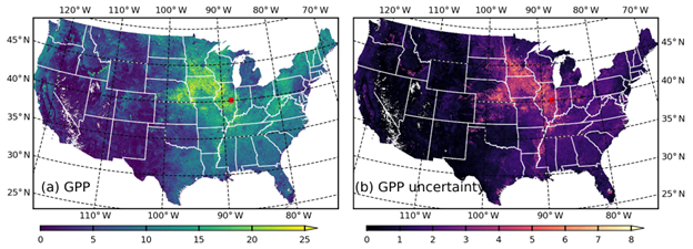
The SatelLite Only Photosynthesis Estimation (SLOPE) GPP product is a daily, 250 m GPP dataset covering the Contiguous United States (CONUS) from 2000 to present with 1 day latency. Gross primary productivity (GPP) quantifies the amount of carbon dioxide (CO2) fixed by plants through photosynthesis. Although as a key quantity of terrestrial ecosystems, there is a lack of high-spatial-and-temporal-resolution, real-time, and observation-based GPP products. This product has been developed to address this critical gap, leveraging a number of MODIS land and atmosphere products. There are three distinct features of the SLOPE GPP production algorithm. (1) SLOPE couples machine learning models with MODIS atmosphere and land products to accurately estimate PAR. (2) SLOPE couples highly efficient and pragmatic gap-filling and filtering algorithms with surface reflectance acquired by both Terra and Aqua MODIS satellites to derive a soil-adjusted NIRv (SANIRv) dataset. (3) SLOPE couples a temporal pattern recognition approach with a long-term Crop Data Layer (CDL) product to predict dynamic C4 crop fraction. PAR, SANIRv and C4 fraction are used to drive a parsimonious model with only two slope parameters to estimate GPP along with a quantitative uncertainty on a per-pixel and daily basis. The slope GPP product has a R2 = 0.84 and a root-mean-square error (RMSE) of 1.65 gC m-2 d-1, evaluated against from 50 AmeriFlux eddy covariance sites (332 site-years). Archived data from 2000 to 2019 are publicly available at the NASA’s Oak Ridge National Laboratory Distributed Active Archive Center (ORNL DAAC). Data from 2020 are available from the authors upon request. All data are projected in the standard MODIS Land Integerized Sinusoidal tile map projection. Each processing tile is in size of 4800 pixels by 4800 pixels, representing approximately 1200 km by 1200 km land region. In addition to the GPP product, SLOPE PAR, SANIRV, and C4 fraction, along with their uncertainties, are also released.